As Storm Aghon continues to linger over Quezon province, the tropical cyclone rapidly intensified into a typhoon on Sunday evening (May 26th), said the Philippine Atmospheric, Geophysical and Astronomical Services Administration (PAGASA).

Winds increased to 120kilometers per hour, with gusts reaching 180kph.
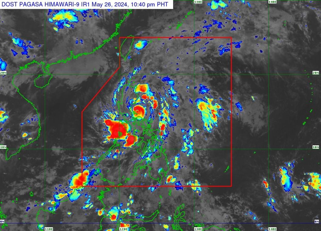
The tropical cyclone bulletin released at 11pm, PAGASA said Aghon was located over the coastal waters of Burdeos, Quezon, moving in a northeastward direction.
Aghon has been lingering over Quezon province since 4 a.m. on Sunday.
Due to its severe winds, Tropical Cyclone Wind Signal No. 3 remains in effect in the Polillo Islands.
Meanwhile, Signal No. 2 is still raised over Aurora, the northern and central portions of Quezon, and the northern portion of Camarines Norte.
Signal No. 1 also remains in place in Metro Manila, the eastern portion of Isabela, the eastern portion of Quirino, the eastern portion of Nueva Vizcaya, the eastern portion of Nueva Ecija, the eastern portion of Pampanga, the southeastern portion of Bataan, Bulacan, Rizal, Cavite, Laguna, Batangas, the rest of Quezon, Marinduque, the rest of Camarines Norte, and the northern portion of Camarines Sur.
Heavy rainfall
In its 5pm (local time) forecast, PAGASA said Aurora, Quezon, Rizal, Laguna, and the eastern portion of Isabela may continue to experience stormy weather conditions over the next 24 hours due to Aghon.
The agency has issued warnings regarding potential flooding or landslides resulting from heavy to intense rainfall, along with a minor to moderate threat to lives and properties due to strong winds.
Meanwhile, rains and gusty winds may persist in Metro Manila, Nueva Ecija, Pampanga, Bulacan, Bataan, Cavite, Batangas, Oriental Mindoro, Marinduque, Camarines Norte, Camarines Sur, and the rest of Cagayan Valley.
There is also the possibility of flooding or landslides due to moderate to heavy rains, along with a minimal to minor threat to lives and properties due to strong winds.
The trough or extension of the severe tropical storm may also bring cloudy skies with scattered rain showers and thunderstorms to Western Visayas and the rest of Luzon.
PAGASA also warned of possible flooding or landslides due to moderate to heavy rains.
For the rest of the country, expect partly cloudy to cloudy conditions with isolated rain showers due to localized thunderstorms.
Track, intensity
The cyclone had made nine landfalls: Homonhon Island and Giporlos in Eastern Samar at 11:20pm on May 24th and 12:40am on May 25th, respectively; Basiao and Cagduyong Island in Catbalogan, Samar at 4am and 5am on May 25th, respectively; Batuan and Masbate City in Masbate province at 10:20am and 10:45am on May 25th, respectively; Torrijos, Marinduque at 10pm on May 25th; Lucena City, Quezon at 4:30am on May 26th; and Patnanungan, Quezon at 7pm on May 26th.
PAGASA said Aghon is expected to continue intensifying over the next two days as it accelerates northeastward over the Philippine Sea.
Based on the track forecast, the typhoon is projected to exit the Philippine area of responsibility (PAR) on Wednesday afternoon or evening, May 29th.
Outside the PAR region, Aghon will continue its northeastward track towards the sea south of mainland Japan.
In addition, PAGASA said a weakening trend may begin by Thursday, May 30th.
Under Signal Number 2 are Alabat, Perez, Quezon, Gumaca, Lopez, Macalelon, General Luna, Unisan, Pitogo, Plaridel, Agdangan, Padre Burgos, Atimonan, Mauban, Real, General Nakar, Infanta, Sampaloc, Pagbilao, Calauag, Lucban, City of Tayabas and Lucena City in Quezon province, including Polillo Islands.


Leave a comment